 Skip Nav
Map Of St.John's City Grid
St. John's is the capital city of Antigua and the center of business, government and commercial activities in the country. St.John's Town was laid out on a grid pattern in 1702 and raised to the dignity of a city In 1842.
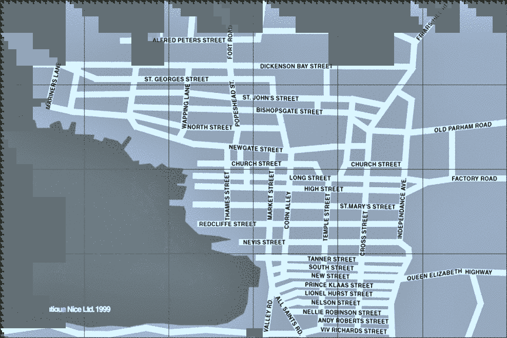
Find your way around the city can be difficult if the roads and street names are not clearly written and visible for all to see. The table below is a detailed list of the names of all the streets, avenues, and Roads in the city of Saint John's Antigua.
Streets In St.John's Antigua
- Mariners Lane
- Alfred Peters St
- Fort Road
- Dickenson Bay St
- St.Georges St
- Wapping Lane
- North Street
- Popeshead St
- St.John's Street
- Bishopsgate St
- Friars Hill Road
- Newgate Street
- Old Parham Road
- Church Street
- Thames Street
- Market Street
- Corn Alley
- Long Street
- High Street
- Temple Street
- St.Mary's St
- Independence Ave
- Cross Street
- Factory Road
- Redcliffe Street
- Nevis Street
- Tanner Street
- South Street
- Queen Elizabeth Hw
- New Street
- Prince Klaas St
- Lionel Hurst St
- Nelson Street
- All Saints Road
- Valley Road
- Nellie Robinson St
- Andy Roberts St
- Vivian Richards St