 Skip Nav
Colonial Relics
English Harbor is the most historic part of Antigua. Time should be taken when visiting Nelsons Dockyard, to follow the path to Fort Berkeley. It is only a ten-minute stroll each way and the unfolding views of the harbor are spectacular. The fort is placed on the peninsula forming the west entrance to English Harbor. It was started in 1704, or 21 years before the Dockyard was built.
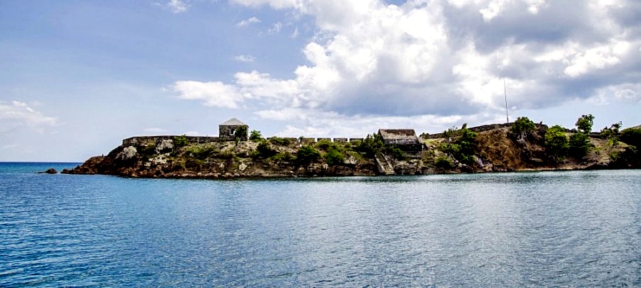
Its defenses were later extended in the 1740s. In this strategic position, the fort commanded the entrance to the anchorage, where naval captains careened their ships and sheltered from hurricanes. On approaching the battlements from a footpath starting at the Dockyard dinghy wharf, a stone quarry may be seen on the right.
It was here that the building material for the fort was taken. The fortified line, once known as the "Charles Line", is further to the right. It was named after Commodore Charles Knowles, who once commanded at the Dockyard. He added this line of battlements in 1745, when the fort was extended. On the left is a bombproof powder magazine, built in 1811 to hold three hundred barrels of gunpowder. Inside the entrance is a cooperage and shifting room for packing explosives. The next building was the guardhouse, for which there is an amusing 18th century reference to this building.
"The Guard is in great distress, the allowance of 9 pence a day not being sufficient at such a cold post to buy more than warm liquor."In 1989, the building was re-roofed by the National Park as a pilot restoration-training project funded by Canada. The restoration is accurate to the point that the stonework shows smaller stones were used to extend the wall height. In 1751, the roof had been blown off by a hurricane. Therefore added height to the walls was needed to accommodate extra beams to strengthen the roof against future hurricanes. The restored mechanics of the inside structure demonstrates great strength, and it certainly survived the great hurricane "Luis", experienced in 1995.
At the end of the peninsula is the site of the first 1704 battery. Peeping out of the battlements towards Guadeloupe is a twenty-four pound cannon, cast in Scotland during the reign of George III of England in 1805. Look for the Kings cipher on the top of the cannon and the date will also be seen. The calibre of the gun is 5.5 inches and it weighs twenty-five tons, taking eleven men to handle it. Its range was one and a half miles with an eight pound charge of gunpowder.
Over the wall at the extreme end, is an upturned cannon cemented in the rock. A chain was once attached and extended across the harbor entrance forming a boom to discourage the entry of attacking ships. The chain was lashed to old condemned masts, preventing it from sinking to the bottom of the Surrounded. With this gun in the round bastion in which you are now standing, and extending along the lines, were twenty other guns. Fortunately, English harbor was not attacked so the fort was never used in earnest, though it must have been a deterrent against assault.
On the east side of the harbor above the "Pillars of Hercules" (q.v. under Natural Sites) it is just possible to see the walls of a half moon shaped battlement. This is the only remnant of Fort Charlotte built at the same time as Shirley Heights military complex visible high up overlooking English harbor. From this walk along the peninsula protecting the western side of English harbor we can understand how well English harbor with its vital naval dockyard was defended against attack, an attack that never happened as it was deemed too strong militarily.